At 10:46 p.m. on March 11, 2011, an alarm pinged on geophysicist Dale Grant’s work computer in Golden, Colo. An earthquake had struck Japan’s northeast coast.
“I knew it was big right away,” said Grant (Geol’79), a senior seismologist at the U.S. Geological Survey’s National Earthquake Information Center (NEIC). “We needed to figure out when, where and how big. Quickly.”
As the only 24/7 earthquake team of its kind in the U.S. — and one of the world’s best equipped — Grant and the NEIC team are among the first to gather key details in a quake’s immediate aftermath and relay it worldwide.
Grant assigned two colleagues to monitor the aftershocks, which could cause more shaking, damage and casualties. The remaining five personnel answered a surge of incoming media calls.
Meanwhile, Japan reeled from six minutes of trembling.
Analyzing seismometer data, Grant worked to determine the depth of the quake — the closer to the surface, the greater the risk of damage. Based on its coastal location, off Honshu, tsunami risk was also high. The Japanese needed to prepare for more that might come.
Within 20 minutes, all the team’s analyses were public: Everyone from the White House to scientists to the public throughout the world knew what the team knew.
With the quake’s exact location and magnitude, the NEIC released information about its estimated impact, including potential causalities and economic loss for the area after the shaking, based on its existing structural environment and population numbers.
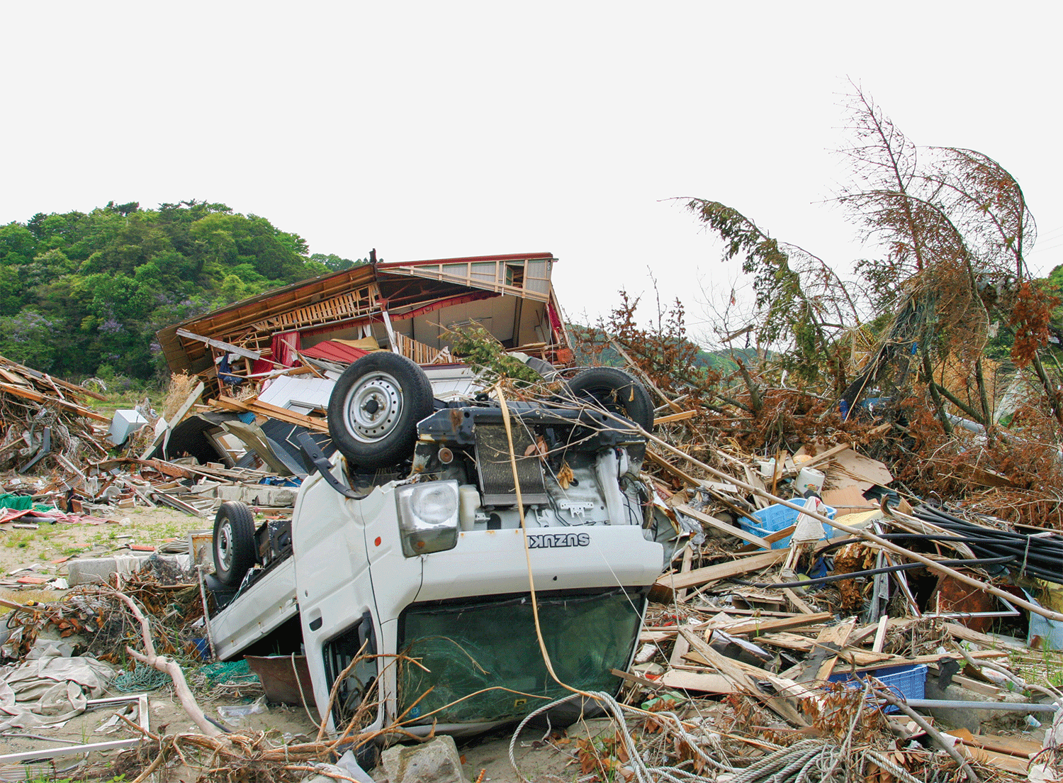
At magnitude 9.1, the earthquake — soon known as the Tohoku earthquake — was the largest ever recorded in Japan and the fourth most powerful worldwide. Within an hour, tsunami waves devastated the coast.
Ultimately it became clear that the Fukushima Daiichi Nuclear Power Plant was damaged and a nuclear meltdown was underway. Nearly 16,000 people died in the quake’s aftermath, and the NEIC located nearly 2,400 aftershocks of magnitude 4.0 or greater in Japan in the following year.
“It was very intense,” said geophysicist Carrieann Bedwell, a CU Denver grad who did most of her high-level geology studies at CU Boulder and was on duty at NEIC the night of the quake.

An earthquake can happen near the surface or as deep as 400 miles inside the planet. Its magnitude determines whether people will feel it or not.
In the aftermath of catastrophic earthquakes, the NEIC, where geophysicist Julie Dutton (Geol’97) also is a member of the team, records every detail about the event, including specific location, damage, casualties, buildings destroyed, landslides and tsunamis.
“Nearly every seismologist in the world is linked to [their] system via text messages,” said CU Boulder geological sciences professor and earthquake expert Roger Bilham. “For damaging earthquakes greater than magnitude 6.5 that have occurred near cities, it is often possible to assess damage remotely many days or weeks before local communities can do so.”
Devastating earthquakes are rare, but earthquakes are not, keeping the team busy.
Worldwide there are on average about 1,000 earthquakes of notable magnitude (about 4.0) each month, according to USGS. An earthquake occurs when two of earth’s tectonic plates suddenly slip by each other on a fault, a break in the earth’s crust. Bound-up energy is then released in the form of seismic waves, which shake the ground as they move through it.
Seismometers, instruments set up worldwide to detect and document earthquakes, record all seismic activity. Scientists use their data in real-time and in subsequent analyses.
An earthquake can happen near the surface or as deep as 400 miles inside the planet. Its magnitude determines whether people will feel it or not. Bedwell once noticed a trace amount of movement in her Golden office from a magnitude 5.3 earthquake that occurred in Telluride, more than 300 miles away.
Worldwide there are on average about 1,000 earthquakes of notable magnitude (about 4.0) each month.
“I was so excited about that one,” said Bedwell, a mother of two who works the night shift full time. “My earthquake notification was going off on my computer and all of the sudden, it said ‘Colorado.’”
All U.S. earthquakes with a magnitude of 2.5 or greater are publicly announced by the team, as well as earthquakes abroad of 4.0 magnitude or greater. For bigger quakes — such as 2016’s magnitude 6.6 quake in population-dense Italy — the team has a direct call line to the White House Situation Room, the U.S. Departments of State and Interior and Federal Emergency Management Agency.
“They are expecting our phone call,” said Grant, an adventurer who spent years traveling the world studying earthquakes beginning in the 1980s and has worked in the NEIC for nearly 16 years. “They want to know if we have any other information on damage or casualties.”
When the team isn’t compiling and releasing information real-time, they catalog smaller earthquake readings. Researchers and universities worldwide use their information for hazard maps, fault models and to infer what’s happening inside the earth.
“For small earthquakes, it is important to know where they occurred, since sometimes small earthquakes offer clues about future trends, especially near volcanos,” said CU’s Bilham.
If you look back on the last 40 years, this is normal." — Dale Grant
There is no way to predict an earthquake — nor, say Grant and Bilham, will there ever be, as it’s impossible to predict when stress in fault regions will rupture.
“In some rare cases, we have quakes in the middle of plates that should never have quakes but still do,” said Grant. “These are still not well understood.”
However, it’s possible to evaluate where a damaging earthquake may be overdue based on past fault line activity, said Bilham, who studies historical earthquakes and earthquakes’ effects on cities, especially in the Himalayas and India. Certain areas — such as Japan, Indonesia, China and Iran — are more prone because of their density of active faults.
“This is actually more important than prediction, because you can build better houses,” he said.
For Grant and many others, the seismically active San Andreas fault on the West Coast remains a serious concern.
“We’ve had some big quakes in San Diego and the San Francisco area, but Los Angeles has been really quiet,” he said, and a big earthquake in that area during our lifetime is a real possibility.
If it seems like earthquakes have been in the news a lot — Italy, New Zealand and Fiji have all had serious ones recently — it’s not because they’re happening more often, according to Grant. Midrange magnitude quakes may be getting attention simply because there are more seismometers gathering data, he said.
“If you look back on the last 40 years, this is normal,” said Grant.
But as long as we live on this planet, we’ll be dealing with them.
“It’s just the earth doing its thing,” he said.
Christie Sounart (Jour’12) is associate editor of the Coloradan.
Source: USGS
Related Articles

Inquiry: Lori Peek

Bringing Down the House

