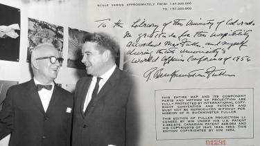
The legendary designer, innovator and futurist Richard Buckminster (Bucky) Fuller, spoke at the University of Colorado’s 1956 Conference on World Affairs.
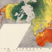
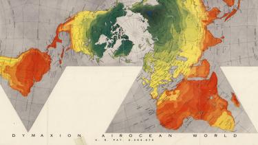
He then donated a signed copy of his famous "Dymaxion Airocean World” map print to CU Boulder, in gratitude for the university’s hospitality during the conference. That map currently resides in the University Libraries Rare & Distinctive Collections (RaD).
“The Dymaxion Airocean World” map is an important item to both our map collection and the archives of the Conference of World Affairs because it places this important figure in American design and innovation at one of the university’s signature events early in its history,” said Kate Tallman, assistant professor and interim lead for RaD. “Fuller returned many times to the Conference of World Affairs and we have in the CWA archives many recordings of his speeches and other historical items.”
Fuller was an architect, systems theorist, designer, inventor, philosopher, writer and futurist. He coined the term geodesic and is credited with popularizing the idea in the United States. Fuller spent his long career focused on ‘alleviating the maximum of human problems with the minimum of material resources.’
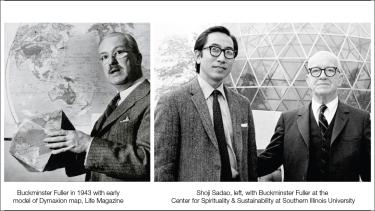
His Dymaxion Map projection was one such endeavor. Fuller believed that the maps in current use tend to emphasize continental isolation. This causes humanity to “appear inherently disassociated, remote, self-interestedly preoccupied with the political concept of ‘its got to be you or me; there is not enough for both,’' states the Buckminster Fuller Institute. Fuller’s map projection was designed to counter that perception by illustrating the continents as radiating from a unified point. This signified that humanity moved together through space, unified with similar problems and similar potential. He called this concept, Spaceship Earth. It took decades to complete, and Fuller relied on aid from one of his graduate students, Shoji Sadao, to finish the project.
Detail University of Wisconsin Milwaukee
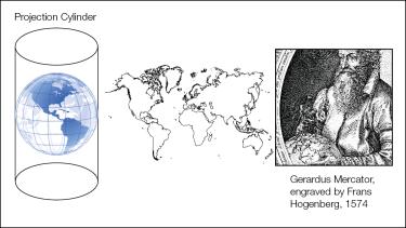
In contrast, the more familiar Mercator projection (developed in 1569 by Gerardus Mercator) is a cylindrical projection. While there is only a slight distortion of the continents at the equator, the distortion expands with increasing latitude and enlarges the sizes of Greenland, Antarctica, Canada and Russia.
Graphic design by CU Boulder Libraries Communications
Explore map projections
The Map Library has books on projection such as An Album of Map Projections and Map Projections – A Working Manual both by the U.S. Geological Survey. These books include many types of mathematical projection formulas in addition to representations of how these formulas produce the projections.
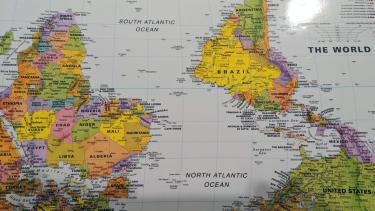
“The process of projecting a globe into a flat map will distort shape, size, direction or distance, in varying amounts. For example, some projections preserve accurate land area at the expense of land shapes. A projection is chosen depending on the purpose of a map, so there’s a chance biases will be reinforced by the resulting distortions,” said Naomi Heiser, map curator and metadata projects manager. “No matter the projection, it’s typical that world maps are oriented with north as ‘up.’ But, if you live in the southern hemisphere and want your part of the world to be central, there’s no reason a map can’t be oriented ‘upside-down’.”
"What's up? South!" world map, ODT Inc., 2015, from the Map Library collection.
The Waterman Butterfly projection below inspired one of Charlotte Bassin’s artworks, which have traditionally been based on the Mercator projection.
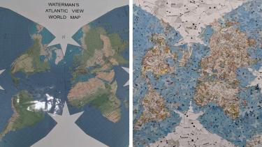
Detail Waterman (left) Bassin (Right)
Learning about projections from Geography Professor Sarah Kelly, Bassin was inspired to produce a global map made of collaged butterfly silhouettes for the No Boundaries show currently showing at the Map Library. In her artist’s statement, Bassin said, “Choosing a map projection is a challenge for cartographers…every map has some sort of biases and distortion.”
Browse the Map Collection
The Earth Sciences & Map Library in the Benson Earth Sciences building is open Monday through Friday between 9:00 a.m. to 5:00 p.m. If you would like to use maps as a primary source in your next creative or scholarly project contact rad@colorado.edu to schedule an appointment with librarians Ilene Raynes and Naomi Heiser.